


Sainte Anne de la condamine

thomas1986
User
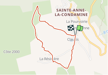

Length
2 km

Max alt
1961 m

Uphill gradient
91 m
Km-Effort
3.3 km

Min alt
1860 m

Downhill gradient
95 m
Boucle
Yes
Creation date :
2024-09-01 17:43:14.637
Updated on :
2024-09-01 18:22:45.638
39m
Difficulty : Easy

FREE GPS app for hiking
 SityTrail
IGN / Geographical institutes
SityTrail Plus
The world is yours!
About
Trail Walking of 2 km to be discovered at Provence-Alpes-Côte d'Azur, Alpes-de-Haute-Provence, La Condamine-Châtelard. This trail is proposed by thomas1986.
Photos


Positioning
Country:
France
Region :
Provence-Alpes-Côte d'Azur
Department/Province :
Alpes-de-Haute-Provence
Municipality :
La Condamine-Châtelard
Location:
Unknown
Start:(Dec)
Start:(UTM)
318705 ; 4926111 (32T) N.
Comments